This was the last link up with Hugh & Tammy while on their marathon travels, before they set off for a couple more stops and head home to Australia in late Jan '25. It was originally intended that Jean would join us on the trip but she was unable to do so.
Our route will take us overland, starting and finishing in Tunis. Although
Tunisia sells itself as a beach and sunshine tourist destination, our emphasis
was to be on its history and culture. It is part of the Maghreb, the western Arab world of Tunisia, Algeria and Morocco. Though it is relatively small in size, Tunisia has great environmental diversity due to its north–south extent. Its east–west extent is limited. The Atlas mountains encroach to its northwest but the south falls away to the Al Jifarah Plain, which borders Libya to the east and the Sahara to the south and southwest.
On leaving the airport, it all seemed familiar, even though I had never been to Tunisia - the sounds, the smells, the traffic competing for space and the horns! But, it was clearly not exactly the memories I had of other Arab countries I have lived in or visited. The dress was more mixed, more Western on balance, the features were more varied and the heights, particularly of some ladies. As my taxi crept through the narrow cobbled streets near the hotel, I was struck by the smell of baking bread and pedestrians carrying bags of baguettes. The French influence was to be seen all around.
Our first venture out was a walk around the immediate area of our hotel in the Medina (Old Town). Lovely cobbled streets, leading out to a major square with Government buildings, mosques, the central market and interesting little shops and cafes along the way. |
| Hugh & Tammy outside our hotel |
 |
| Lots of cats everywhere |
 |
| Chechia (African) souvenir hats |
 |
| Real Chechias being ironed |
The weather was rather blustery and there was a little rain at times. We dined out at the Dar el Jeld restaurant next door, which read to be highly rated. After a rather gruff and disjointed welcome, we started to walk out, but were persuaded to resume. The famed Tunisian food there turned out to be a deep disappointment with lamb that must have been walked miles to slaughter in its later years but we did discover a fine Tunisian red, Kurudis!
 |
| Decor was good |
 |
| Our table was fine |
 |
| Starters were ok |
Next day was all about Tunis and Carthage and their mixed history from Berber, Phoenician, Roman, Byzantine, Arab, Ottoman, Moorish, French and Italian times, starting with the ruins of Carthage. Initially destroyed and buried by the Romans, but then rebuilt by them. However, the remains are scattered and much is disconnected as the unearthing and rebuilding was lacking.
 |
Tomb of King of France
St Louis IX |
 |
| Sanctuary Punic |
 |
Headstones of infants
immolated by the Phoenicians
in child sacrifices.
Rather chilling. |
 |
| Cremation chamber |
 |
| Punic Port of Carthage |
 |
Roman Baths
an enormous complex with separate
male and female chambers of hot and cold
rooms, gyms and a pool |
 |
| Roman Aquaduct |
There were many sites of ruins the area consisting of broken columns and other bits of structures.
 |
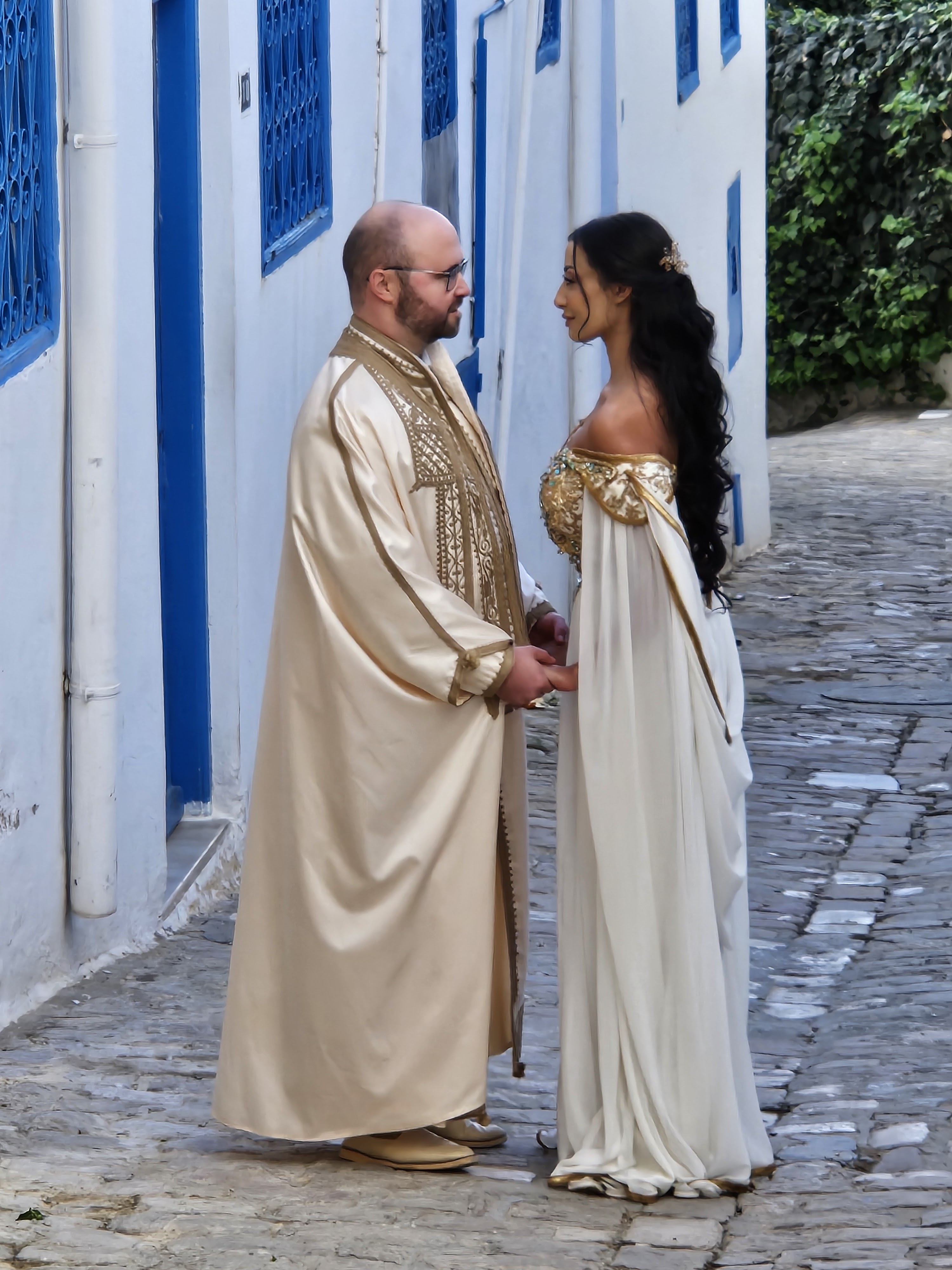
Couple about to be wed
Polish to Tunisian |
 |
Sidi Bousaid house
with its regulation white & blue |
 |
| Exception - Government building! |
 |
| Sidi Bousaid marina |
 |
| 5* Hotel Blue |
We enjoyed grilled fish for lunch in Popeye's restaurant in 'Little Sicily' overlooking a pretty beach, and Bamblouni, very sugary local doughnuts, in Sidi Bousaid.
Then, it was onwards out of Tunis, first to the township of Testour, where we visited an interesting mosque, which had been built to serve both the Muslim and the Jewish communities for worship, on different days (Friday& Saturday). The clocktower features each of the Berber, the Star of David and Islamic styles.
If coexistence and sharing of facilities can be so easily and peacefully achieved here, why not elsewhere?
It was here that faith was further restored in humanity. Hugh realised he had lost his phone, some time after doing so. Anis, our guide, rang it from Tammy's and a chap answered who was waiting at the mosque, probably for over half an hour since we had been there. He handed it over, saying that he had waited for the call, tapped his heart when thanked, and went on his way, well!
 |
Testour
a place of fruit |
 |
All kinds of nuts for sale,
some solidified in toffee |
 |
| Young lad having a shave |
 |
| Pomegranate |
 |
Coffee in the market square
in Testour |
 |
Lunch at a family home
in Teboursouk |
Onward to Dougga, or Thugga, a Berber, Punic and Roman settlement and UNESCO world heritage site. It was founded in the 6th century and includes many parts - forum, baths, temples and accommodation - in addition to the theatre.
 |
| Dougga Roman Theatre |
 |
| The Forum |
 |
| Communal loo! |
 |
Olive oil press
nearby |
 |
| Dispensing the olive oil |
Then it was onwards to Kairouan, which we didn't make until after darkness, and checked in to La Kasbah hotel. A light dinner and a couple of beers finished the long day off nicely.
 |
La Kasbah
built inside an old fort |
More and more I was impressed with the friendliness of the Tunisian people, male and female, relaxed and open to spontaneous greeting and conversation where language permits. It really is a warm and welcoming place. French remains pervasive in both language and signage, but many also speak English, which is taught as a 3rd language.
First visit of the morning was to the Maulsoleum of Abu Zama'a al-Balawi, a Berber and companion of the Islamic Prophet Muhammad, at the 4th holiest site of the Muslim World. It dates from the 9th century. 7 visits here can substitute for a Hajj visit to Mecca.
 |
Water reservoir
piped from a nearby mountain
by aqueduct |
 |
Mosque
with prayer schedule on display |
 |
Tomb
of Abu Zama'a al-Balawi |
Last, it was a visit to the Grand Mosque before we set off from Kairouan to Tozeur, some 5 hours drive southwest.
 |
| Extract from the Quran |
 |
Started in 670
Enormous door |
There was a gradual change to the scenery along the way, greener and cultivated areas giving way to a sandy and arid landscape as we neared the northern edge of the Sahara.
 |
Shawarma sandwich stop along the way
Freshly prepared and very good! |
 |
| Sheep double decker transport! |
 |
| Changing landscape |
 |
| Entrance to Tozeur |
 |
Dinner out
at Dar Deba |
 |
Earthenware carafe of wine
brought in from elsewhere
and served in goblets |
 |
Hugh's Dromedaire casserole
in its earthenware pot |
 |
My dish of Chakhchouckha Royal
thin chapati pieces, nuts
and chicken |
 |
| Restaurant Dar Deda |
Tammy and I joined a chef to buy some vegetables in the local market, for a lunch preparation later, before taking a ride to Eden Palm Oasis, a 2million hectare area growing dates and other fruits. The dates are delicious in Tunisia, large and sweet.
 |
| Ahem, the knives were blunt! |
 |
| Lunch is served! |
And in the evening, we returned to Dar Deda for dinner. Food was fine, there was a bit of a chill al fresco, which was not sufficient to dull the corked wine that had been brought in with no return mechanism!
A short distance away from Tozeur, we stopped at an abandoned set that was used for a Star Wars film, the spaceport Mos Espa, near Ong Jemal in the desert. It was fascinating to see what can be achieved quite simply, albeit a long way from anywhere, even if it is showing some signs of weathering after many years.
 |
Drifting sand that
encroached onto the road |
 |
Mos Espa
viewed from a dune nearby |
 |
| The inside! |
 |
| Dune near Mos Epsa |
 |
A good viewpoint
but not much of the canyon itself
is visible from here |
 |
| Algeria beyond |
 |
| Sand crystal cluster |
Last of all, we visited the Chebika Oasis and its waterfall.
 |
| Village alleyway |
 |
Buttressing added after
the village was destroyed in 1979
by flood & avalanche |
 |
It was a bit of a scramble
at times! |
We took a day of touring to wander around the old town of Tozeur, finding an antique shop where Hugh (eventually after much bartering) made a purchase, then enjoyed being entertained by a lady who showed us around her musuem, with demonstrations and ululations, where she also dressed up Hugh & Tammy to renew their wedding vows!
 |
Antique shop saleman
with "Freedom" markings
on his suit (also seen elsewhere) |
 |
| Carpet shop in the Medina |
 |
| Antique shop |
 |
| HMV! |
 |
Departing the antique shop as
bartering spills into the street and is
joined by the carpet shop salesman! |
 |
| Flower grinding stone |
 |
| Camel skin bucket |
 |
| Henna hands |
 |
They do, or did, again!
(renewed) |
 |
| Wool spinning by hand |
 |
| Medina street |
 |
| Says it all?! |
 |
Shawarma sandwich preparation
essentially a closed pizza
quickly prepared |
Heading east from Tozeur, we crossed 75km of the Chott el Djerid salt lake, stopping at a salt mine en route.
 |
| Colours vary |
 |
| A few sculptures along the way |
 |
| Berber man making bread |
Onwards, we stopped for a coffee, then Douz for lunch, which included some excellent grilled chicken.
Sabine is a great cook so we enjoyed courses of superb food for dinner and breakfast the next day. Patrick is French and was involved in the hospitality industry until the collapse of tourism in 2015 after the terrorist attacks. He has found a fine niche here in Tamezret. Only 3 rooms.
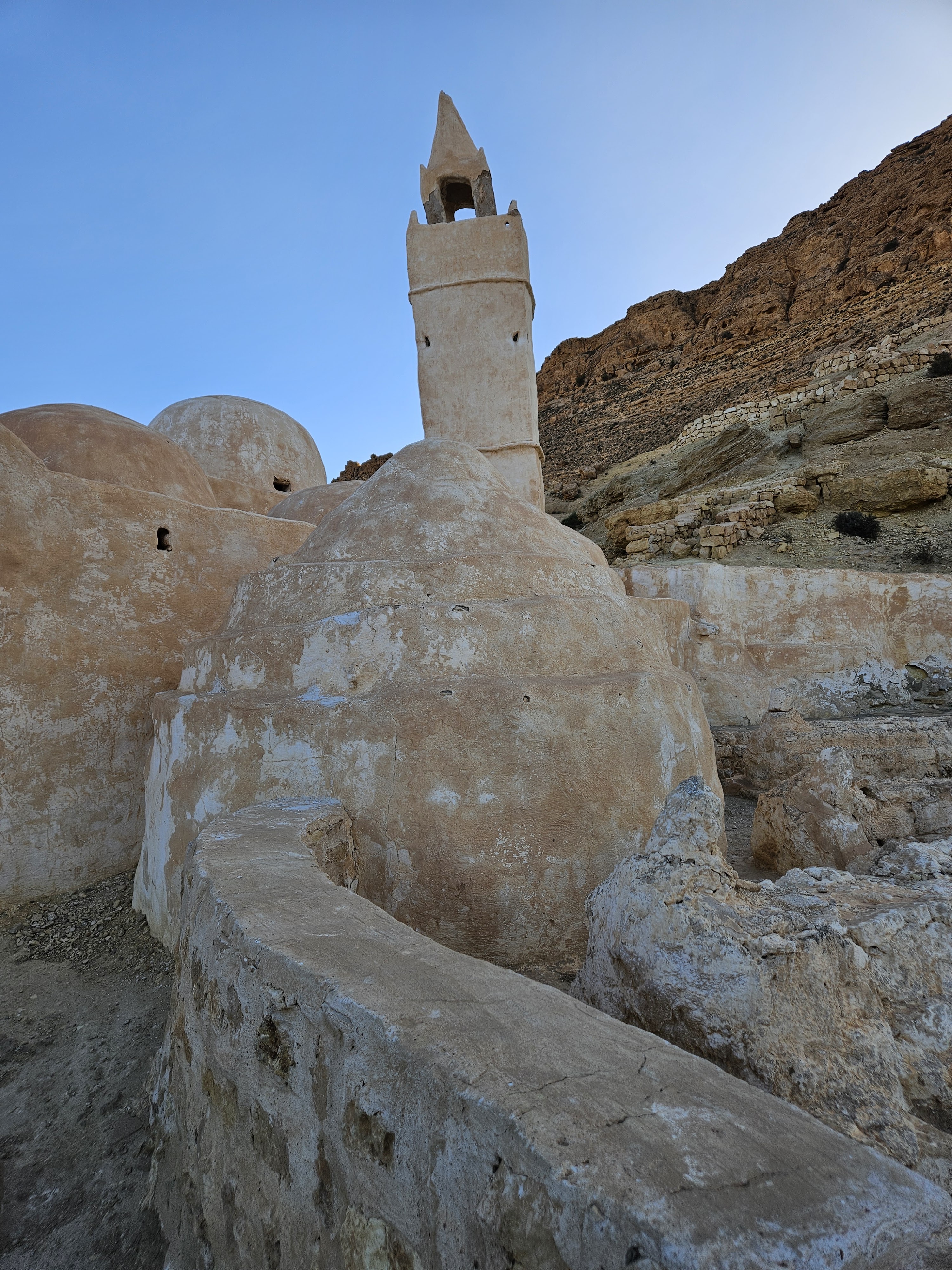
A short drive from Tamezret is the Berber village with its underground dwellings centred on a courtyard, and we enjoyed a short stop there.
 |
| Our driver, Hugh, our guide Anis, me |
 |
| Dwelling entrance |
 |
| Courtyard |
The terrain changed to twisting roads, ascending and descending hills as our journey continued east.
We stopped at the Hotel Sidi Idris, which was used as accommodation for some of the Star Wars cast, climbing to a coffee stop above Toujan and on to another Star Wars Berber village, being converted to a hotel, Ksar Hedada, where The Phantom Menace was filmed in1997 and it too was used as the set for Mos Espa.
 |
| Shawarma sandwich lunch |
Last of the Berber villages at Chenini was quite outstanding, stretching high on the hillsides with many dwellings, although some were in a bad state of repair. Most have a small courtyard at the front with the rooms extending back into the rock through a single entrance.
Last stop of the day before driving on to Djerba Island on the east coast, was the Mosque of the 7 Dormants. It is said that a small group of believers took refuge here to flee persecution and then fell asleep for 300 years to await a more clement period, according to legend. It has a number of 4m long tombs which remain inexplicable to this day, among several hundred excavated from the 5th and 6th centuries.
 |
| The long graves |
Crossing more salt lake and then a Roman sea bridge across the channel to Djerba, we then checked in at the quite contrasting (to our troglodyte stop at L'Auberge) Hasdrubal Prestige Hotel on the north coast of Djerba Island. The hotel suites are enormous and all the same, and there were just a handful of people staying - it was positively agoraphobic!
Next stop was a pottery shop, claiming to be the biggest jar in the World. The work on display was varied and impressive.
 |
| Fantastic ceiling |
 |
Market with
very fresh looking vegetables |
 |
| Dates |
There is a very distinctive dress in this area, both men and women wearing woven Berber hats and robes. It is different to anything we had seen elsewhere.
 |
Museum Guellala
displaying customs and traditions
of the people of the area |
 |
Models depicting driving of a nail
into the neck and eating live scorpions! |
 |
| The explanation of the trances of the believers |
Stopping roadside, we watched a small group of ladies picking olives, which are racked onto a net below the tree for gathering later.
 |
Lady picking olives
with the tree |
 |
| Tammy gives a hand |
There are millions of olive trees in Tunisia, although we couldn't work out why some were planted close together while others were much more widely spaced. Maybe it is due to the irrigation of the area or the type of olive tree. The pickers get paid by the tree owner.
Onwards to Djerbahood, the Jewish community of Djerba.
We were given lunch by very friendly hosts, particularly the wife, who seemed to have an especially close friendship with our guide, Anis. There was much laughing and joking between them as we downed a lunch that had been prepared the previous day in line with custom - no cooking on the Sabbath.
We strolled through the streets of Djerbahood where artists had been invited to display their skills with murals, and the practice has been ongoing since then. Only a few were signed.
 |
The walls had been repainted but
the painting in the corner had been
retained on its darker background |
Last of the day was a visit to Houmet Souk, which was very quiet ahead of late afternoon shoppers turning up.
 |
| More Tunisian pottery |
It was a long and circuitous drive from Djerba to Sousse, but along the way we visited the El Jem Amphitheatre, the second largest in the World after the Colosseum in Rome. It was built in 283AD entirey of stone compared the part brick and stone Colosseum. Much of the seating has collapsed over the years, but sufficient and impressive parts remain to show how it was arranged for those games in the past - lower level for gladiators and animals, the tiered seating and the central areas for the fighting and what followed. It was used for part of the filming of Gladiator.
 |
| Two fossils amid some ruins! |
 |
To give scale (Tammy's photo from on high)
Hugh & I are standing in the main arena
barely visible just to the right of the entrance
slightly right of centre! |
 |
| The Tunisian Trio |
Last of all a camel was spotted waiting for customers, who didn't include us!
 |
Jaz Tour Khalef Hotel lobby
and a sundowner |
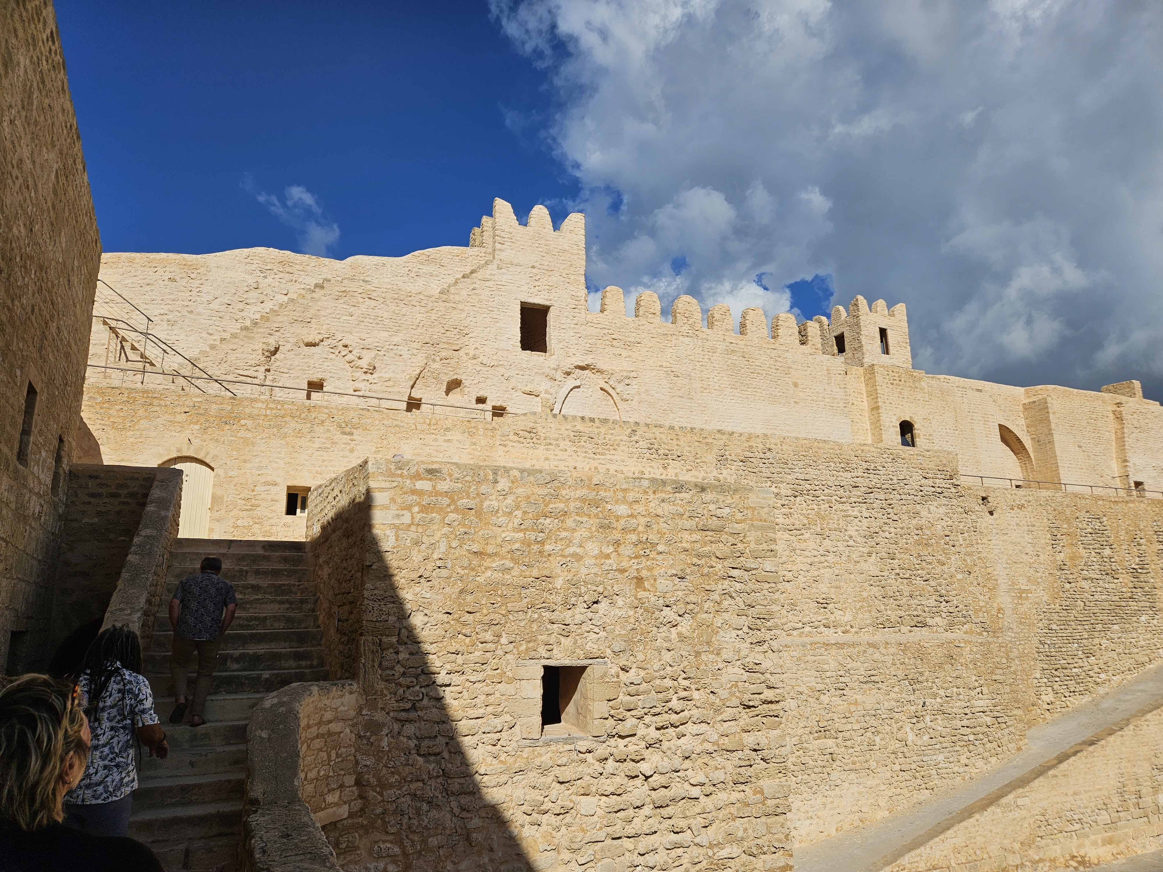
A much welcomed and slower pace today as we took a drive south to visit The Ribat (fort) of Monastir. Although started in the 8th century, it remains in very good condition today, and was principally built to defend attack from the sea. It is the oldest ribat built by the Arab conquerors during the Muslim conquest of the Magreb.
Our last day on our own was more relaxing with no long distance driving and a chance to catch our breath before our onwards journeys.
Hugh and I visited the Archaelogical Museum of Sousse, where we saw some amazing large mosaics that had been discovered and excavated largely intact. How this was done remains a mystery to me.
 |
| Massive pavement mosaics |
 |
Theatre scene
(masks, not heads!) |
 |
Baptism font from the 6th century
which was excavated intact |
 |
Medusa
from Greek mythology and one of 3
'gorgons' born to the sea god
of the dangers of the hidden deep! |
 |
| Missing areas filled with plaster |
 |
Into the Medina
in search of a coffee |
 |
The call to prayer was imminent!
|
Back at the hotel, the quiet of the afternoon was suddenly interrupted by a thunder storm, breaking the run of excellent weather we have enjoyed all trip.
 |
| Rain cascading of the roof |
Fortunately, it had moved on by the time we headed out to a local restaurant, a second visit, for our final dinner.
It was then time to check out, take our transport to Tunis airport and head our separate ways, Hugh &Tammy to Kuala Lumpur to continue their travels, and me to Frankfurt for an overnight and then onwards to Birmingham.
Tunisia has been a great experience with its diverse culture & topography, changing landscape from green & cultivated to desert, its mix of Arabic, French and English languages, the kind weather and, most striking of all, the open welcome and friendliness that seemed wholly natural to its people. In all, we had covered some 1,600km overland and obtained a good impression of the country and its people, and we found that nice Kurudis red in several other stops, including our last.


.jpg)


.jpg)


.jpg)


