We left Deadwood for Lusk, a single strip
town in the middle of nowhere in south Wyoming, but the journey there was
fantastic! First, we stopped at a scenic
spot for a photo by a reservoir:

Then, we rode to get a view and picture of Mount Rushmore to see
the carved heads of the four US Presidents, Washington, Jefferson, Roosevelt
& Lincoln, which was impressive:

However, the carving of Crazy Horse
Monument, which was started in 1948 by one man and, after he died, continued by
his family who have just managed to finish the face in 1998, and it will takes
decades to finish. Crazy Horse was a
local hero who refused to sign any more Treaties because the White Man kept
breaking them - mostly because of gold that was found on the Indian land. When finished, it will stand taller than the
Washington Monument and many other like structures, and be the largest mountain
sculpture in the world. It's just amazing.

So far - the people standing at the bottom of the head are not visible!

The design on the mountain sculpture

What it will look like when finished

Me in the car park in front of the mountain, a long way off
We then headed for Custer, where bikers
were being persuaded to stop by townsfolk all dressed up in the past, onward to
Custer National Park on the Needles Highway, which features pinnacles of rock,
single lane tunnels, forestation and very pretty twisty roads to ride on. It was extremely pretty.

Then, it was a dramatic change of scenery
as we dropped (well actually, still above 5,000') down to prairie land
again, with scrub grass, where we saw wild bison, deer, a couple of huge ones
just by the roadside, which would have been disastrous to hit. Also
keeping us alert was a rather large and fresh amount of bison poop for some
distance on the road until we came across a herd not far from the roadside -
phew! The winds got hot and the road
went on for over 100 miles until we arrived in Lusk for a stop at a motel for
the first of three nights in Colorado, once again showing the size of these
States and what it takes to cross them. We had a great start next day with omelettes
prepared on the lawn in the motel from a chuck wagon, of the sort that used to
accompany the cattle drovers or those driving west in search of a new life.

After
a short ride, we got to the historic site of what had been Fort Laramie, a very
important military post on the Oregon Trail, one of the main arteries of
emigration from east to west as the attraction of a new life (opportunists and
dreamers), freedom (Mormons and others) and the gold rush took place. The
Fort itself doesn't really exist today but what does remain has become part a
National Park and some very good information and exhibits exist in it to
explain its part in history.
Then, it was on to Laramie town, actually
40 miles away. We left the prairie land that Fort Laramie occupies, and
climbed from 4,000' to 7,000' through some of the foothills of the Rockies, to
another plain. I have come to better understand the description of High
Plains, having hitherto only associated it with the Clint Eastwood movie
High Plains Drifter. They are high, they have strong winds both in summer
and in winter, with many snow break fences to stop the snow accumulating on
road and railroad, often up to 100mph. The grass is very scrubby and
Angus cattle suit it well, but we also saw deer, including one doe which ran
across the road in front of John when I was riding no 2 behind him!
Fortunately, it continued and leapt the cattle fence on the other side,
rather than go back, which would have been disastrous. It helped focus
the mind!
We stopped for lunch in Laramie after two
long runs on high plain prairies in hot winds, and a very interesting one in
the first lot of foothills. After that, we found this fascinating place in the middle of nowhere (advertised next beer 50 miles!):

and at the front:

I think she meant it too!

Fascinating picture on the wall with various celebs
including Butch, Sundance, Wyatt Earp and Liver Eating Johnson!

Great place, full of character
From there, we fortunately skirted some
thunder storms on the mountains to our right and rode into Colorado in the
dry, after we had stopped a fascinating and very remote saloon with these signs:

After that, it was with increasing heat and humidity on a section of motorway that was
very slow indeed, that we eventually got to the Thunder Mountain dealership, believed to be the
biggest in the US, in Loveland.
It was a somewhat cloudy but warm day when
we departed Loveland and entered the narrow canyon on the road up to the Rocky
Mountain National Park. But, it was dry.
The canyon was deep sided and narrow and twisted and climbed for quite
some miles, and was a joy to ride through. Next, we arrived at a higher
flat plain, and the air had cooled some, after which we entered the Park.
We were around 9,000' at this point. Following some study of the
map and a target place and time for lunch, we split up to do our own thing for
2 hours.


I climbed for another 1,500', now 2 miles
above sea level and had a couple of stops to take photos, but the clouds were
now looking rather menacing and, after passing a sign with warnings of sudden
changes of weather beyond that point, it kept its promise! The rain
began, the temperature fell to 5°C and a high wind made riding on the Trail Ridge
road far from scenic and enjoyable. I also noticed quite a sudden breathlessness,
not from the scenery in the rain but the altitude! I was a bit surprised
by this as we had been fairly high in recent days and this normally helps cope
with the transition to thinner air. I stopped a couple of times to look
down on small glaciers that were below me, by now over 12,000' and even tried a
couple of photos, but it was really just a question of getting down safely on
the wet road. At 10,500' again and on the other side of the mountain
range, the rain let up but the road remained wet for some distance. What
a shame - it was to have been a high point in two respects!

Snow below me in the rain!
I passed a stopping point at just over
10,000', which was another on the Continental Divide, at La Poudre Pass, which is
also the source of the mighty Colorado River that I had enjoyed in the Grand
Canyon, in what now seems ages ago.

Further down, I was rewarded several
times with large stags at the side of the road, one of whom was doing a number
on a tree with his antlers.

From the Park, we set off for some stunning
riding through some more of the Rockies, more sweeping bends, fantastic scenery
and the sunshine returned. It got better and better and we crisscrossed
the now growing Colorado several times and paralleled it for some distances too.
The final 20 miles were through the
Glenwood Canyon on what must be the most attractive and scenic freeway/motorway
in the World. The Colorado flowed through it, train tracks were
alongside, and the canyon walls rose, by my estimation, more than 1,000'
steeply either side. It couldn't have been a better finish to follow the
disappointment of not being able to savour the Trail Ridge road at its best, but I sadly couldn't take photos as we passed through. We got a good taster for the spread and the height of the Rocky
Mountains. Glenwood Springs is up in
skiing territory and near to the famous Aspen Resort.
It was a lovely cool start the following
morning, heading out of Glenwood Springs to stop at a typical American Diner,
complete with Wurlitzer Juke Box and all the other ambience of the type you see
in the movies. It was very efficient, much better than any recent
restaurant experience, and a fine cooked breakfast was on the table in minutes.

From there, we spent about 50 miles in a
canyon, quite wide for much of it but with a river, which was very pretty with
deep red rock rising either side. After that, we got to a very wide
valley or gorge of a completely different type or rock, very creamy in colour
and the valley floor looked to me as though it was manmade as some of the
mounds looked like spoil from something. In due course after many miles,
I concluded that this was not so although I knew we were in mining country, as
the size of these mounds was so huge. We did pass a few coal mines, but
they were distinct.
Gradually as the miles passed, we got
closer to the large mountains we could see rising in the distance for a long
time. They looked so huge, rising above the valley floor by thousands of
feet, even though we were still around 7,000' to begin with. Finally, we
reached a little town called Ouray, which was nestled at the end of the valley. We rose steeply from this and a stop overlooking it had a sign that the
area we were in was the 'Switzerland of America'.


Above Ouray
We continued to climb to some
of the most dramatic and testing riding I have ever experienced. The road
narrowed some and twisted a turned as it climbed to the first of the passes we
were to traverse today. The craggy rock rose steeply to our left and
dropped perilously to our right, the side we were riding of course! There
were no barriers and anyone with vertigo would have given up or frozen.
On we climbed, passing old wooden mining structures from the past, bits
of spoil from the prospecting and mining until I saw the largest mountains of
iron oxide I have ever seen - giant peaks of rusty rock rising above us.
Sadly, the stop we made to put in liners for the colder air was just past
the best point to photograph them.
On we went and once more the rain came.
We passed Ironton, not surprising given the rust about, although it
seemed only to be an area rather than a developed town. We peaked at around
10,700' in the rain, before a slow descent into Silverton. I'm not sure
if there is a Goldton, but gold and silver mining was big here when the
West was being won. Silverton sits at 9,300', is a very attractive old
town, and hosts the highest H-D dealer in the World, another T-shirt. We
then decided it was best to put wets pants on as well as the sky looked dark in
the direction we were heading.

Silverton Main Street

Mining works and spoil above Silverton
Onward and upward again was next, climbing
back up to 10,640' at the summit of the next pass but the rain fortunately
started to ease as we had a glorious and steady descent on lovely road for the
next 35 miles into Durango, which is still at 7,500'. The issue of height is
quite important because it determines the coolness of the air, particularly in
the evenings, and it helps dimension the relative sizes of some of the peaks
that we have seen around us.
The Strater Hotel is locally famous for its
saloon with waitresses dressed up in old western style and it hosted very good
live country & western music.

The Diamond Belle Saloon of the Strater Hotel, Durango
We headed out from Durango in the cool of
the morning, shortly passing into New Mexico for the first time to continue a
slow descent for the first 50 miles to a place called Farmingo. It was here, still at 5,300', that the
landscape suddenly changed from green to desert, almost as if a line had been
drawn.

For the next 100 or so miles, it
was barren and arid with sand and rock abound, but with mounds of rock rising
up here and there, nothing too dramatic, and very sandy coloured so not very
interesting. The road was straight and
shortly after leaving Farmington, we passed into Arizona for the first time.
Next, we passed into Utah once more, and eventually
arrived at Four Corners Monument, the only place in the US where four State
boundaries intersect in a point and at right angles - Utah, New Mexico,
Colorado and Arizona - inside an Indian Reservation. There is a bronze plaque cemented into the ground
with the four State lines shown in concrete from it in each direction. Photos were taken and we tried our first
Navajo Fry Bread [sic], which was actually quite nice, a bit like a soft
tortilla and coated with powdered sugar, honey or cinnamon. So, 4 States in a blink.


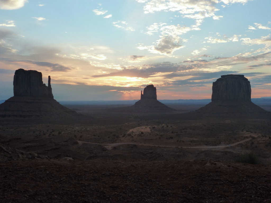
From there we carried on in Utah and
started to see the rising formations of Monument Valley in the distance. I thought they were still miles away when we
came over the brow of a hill to drop into a gully for a while. To say that these formations are awesome is
barely adequate and we weren't yet in Monument Valley.
The road was dead straight for miles at a
time, but it did undulate up and down to bring great views both sides. Very large rocks seemed precariously perched
on the top some of the formations and one such - Mexican Hat Rock - epitomised
them and was close to the road to warrant a stop and photo.

Mexican Hat Rock

The long straight road leads to Monument Valley in the distance
After about 50 miles we got to the turn off
to the View Hotel, the only such place in Monument Valley and on the Indian
Tribal Park. Just before we entered the
gate, we passed back in Arizona for the second time in the day, and checked
into this small hotel almost built, into the rock and very sympathetically
coloured to blend. Every room has a view
over the Valley and the key attraction is to watch the sun go down with the
mesas (the rising towers of rock) in full view, and the sun rise next
morning. Both were fantastic.

The View Hotel

Blends easily with its low profile


At sunset

Sunrise

Departing the View Hotel next morning, we
had just passed 3,000 miles of the trip and crossed back into Utah from
Arizona, only to go a mile or two before we passed back into Arizona!


Looking back the other way into Utah
Then it was onward to catch sight of more
mesas and buttes of Monument Valley as the temperature quickly rose again to 40°C. It was more desert, but the colour, texture
and topography changed as we rode through part of the Painted Desert.

The colours changed from the red of Monument
Valley to cream and grey, then back again to red again as we got closer to the
Grand Canyon. We lunched at a Navajo
Trading Post called Cameron, which has the biggest gift shop of native arts and
crafts I have ever seen, not that I bought a bow, arrows, a peace pipe, a
tomahawk, or any of the mountain of jewellery etc on sale.
Next, it was into the Grand Canyon National
Forest with a rise in elevation to a slightly cooler temperature and the smell
of the pine trees, then the Park, where I got more sights of the biggest hole
in the ground you ever did see as we passed various viewing points.

After dropping luggage at our hotel, those of
us who had booked a helicopter tour over the Canyon headed for the airport very
close by. It was a very enjoyable flight
over a different route to that I had taken from Las Vegas. I was also by an open window so was able to
poke the camera out for good photos and video, so it was definitely
worthwhile. It really is an astounding
piece of geology.


As the sun started to set, we headed back
to the side of the Canyon to watch it set, but it was somewhat limited by cloud
cover and not quite as good as Monument Valley.
Nonetheless, it was an experience not to be missed.

We left Grand Canyon in coolish air that
didn't last very long and, after 50 miles arrived at Williams, our first stop
on the Route 66, the Mother Road, the Main Street of America, for
breakfast. Route 66 doesn't get marked
on US maps anymore, but the history of the road and the efforts of a barber
ensure that it is still popular with tourists, in particular bikers like
us. We enjoyed a great breakfast and
then wandered the town, visiting the Best Little Whorehouse (as was) of
Williams, the Red Garter, next door to our breakfast stop.


The places on Route 66 are otherwise small,
and many have either died or nearly died as freeways have passed them by, but
we were able to enjoy the largest single piece (150 miles) of it that still
exists. We stopped next at Seligman,
where the barber, Angel Delgadillo, drove the recognition and retention of the
history of the road, and his barber shop is now a mandatory stop and purchasing
opportunity for all, with many others trying to mimic it. It was wonderful.


At the end of the town, we stopped at the
Road Kill Cafe - "You kill em, we cook em", or "Nice and tender,
direct from the fender"! The
waiters wear T-shirts with 'Got any Road Kill?' on them and there are some great signs. A place of outstanding character and
atmosphere with a jail and various other old establishments next door.


Then, it was on to Hackberry to the General
Stores.


The General Stores, I think, is
Hackberry, rather than the Stores are in Hackberry. It is an amazing place with lots of old cars,
petrol pumps, an enormous collection of number plates and other Route 66 stuff
to buy, in the middle of nowhere.
The temperature rose to 45° and
that's rather hot for riding, especially when you're stopped at one of the very
few traffic lights above an air cooled engine!
We then went on to Kingham for a stop at the Mother Road H-D dealership and thence to our
hotel. We were taken in the van for
dinner at a local steakhouse, which turned out to be excellent and with
character.


Our last day of riding still didn't
disappoint although it was rather hot again at over 40°. First, we rode across desert to the
Sitgreaves Pass, a twisty one where, in the past, drivers were hired by owners
to take their cars across the pass. It's
a bit better now, but still commanded attention. On the other side, still relatively high at
around 3,000'plus, we found the frontier and mining town of Oatman.


It really is a blast from the past, although
it's survival is more from tourism now as the gold mining that made it famous,
and very famous the area was with $36m mined in the early part of last century,
has all but ceased. It has a gun fight
in the street every day and has lots of old buildings that remain. The name derives from Olive Oatman, a picture
of whom exists over the store of her name, who was one of only two survivors of
her family after an Indian attack at the age of 12. The Indians who killed the rest of her family tattooed her chin and made her a
slave, which meant she lived outside their camp and had to scavenge. She was treated badly until sold to another
and more friendly tribe who eventually accepted a trade with the authorities
for her to be released at the age of 19.
After soaking up the atmosphere of Oatman,
we descended and parted company with Route 66 as we headed down towards the Colorado
River, a much wider one than had seen previously, with paddle driven river
boats in Bullhead City on the border of Arizona/California. From there, we continued on some very hot,
straight and boring road freeway, until we reached the Hoover Dam.

Lake Mead


The low water level, some say with only 8 years left!


Since I last visited it in
the 80's, a massive new highway bridge has been built across the downstream
side and the old road across the dam now only exists to allow visitors to
it.
From there, it was only a short ride to Las
Vegas to return the bikes after 3,585 miles in my case. We had had no breakdowns or issues, which was
good for 9 bikes and one trike.

A sad moment!

No comments:
Post a Comment